I have a layperson interest in seismology, and if I had the patience and genetic gray matter to capably execute math and logarithm formulas I likely would’ve been a scientist — perhaps even a geologist or seismologist. But as much as I find science fascinating, math has never come easy to me beyond basic arithmetic. I blew the lid off my SATs with my English scores, but my math scores were lurking somewhere near the basement, and I never received much academic encouragement to pursue earth science studies.
Nevertheless, a friend recently asked about a story in the Los Angeles Times detailing how the Garlock Fault in Southern California is experiencing, according to the headline, “unprecedented” movement as the result of the magnitude 6.4 and 7.1 earthquakes near Ridgecrest over the July 4th holiday. My friend also asked whether the Garlock Fault is capable of producing a magnitude 8.0 earthquake, as the newspaper headline indicates.
The answer is, yes — the Garlock Fault is capable of a magnitude 8.0, and that L.A. Times story is based on a new study released by Caltech scientists last week.
The Garlock Fault runs laterally across Southern California, essentially from Death Valley National Park at its east end to Tejon Pass along I-5 at its west end. The Garlock is unusual because it’s an east-west trending fault, and most faults in California tend to run northwest to southeast along larger fault systems like the San Andreas and San Jacinto. Most earthquake faults in San Diego County like the Rose Canyon and Elsinore also follow this alignment.
Geologists have been aware of the Garlock Fault for decades, in part because they see the trace of the fault and the impact it appears to have had on the landscape over time. But there haven’t been earthquakes that can be attributed to the Garlock in about 500 years of recorded history, and that includes 130 years’ worth of modern seismology that indicates the fault hasn’t been an active geological factor for centuries. While the Garlock may have played a role in a magnitude 5.7 earthquake near the community of Mojave in 1992, about two weeks after the big Landers Earthquake to the south near Joshua Tree, no evidence of surface displacement was ever found.
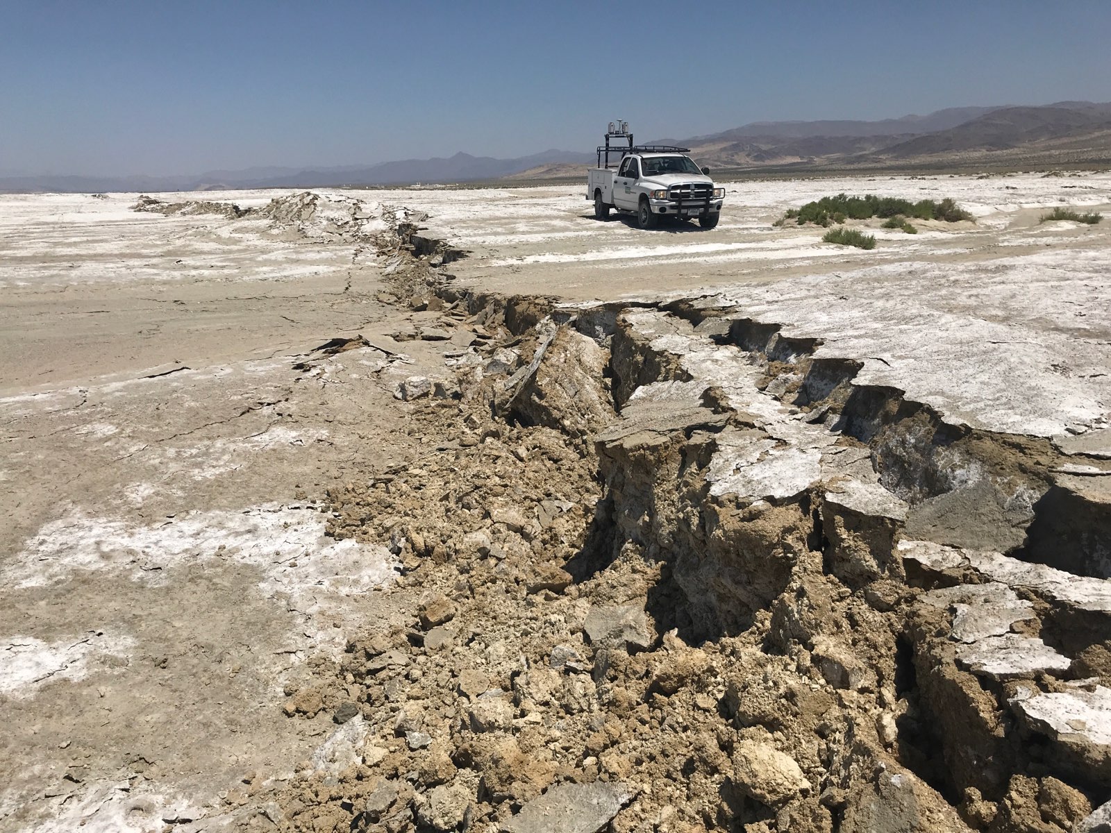
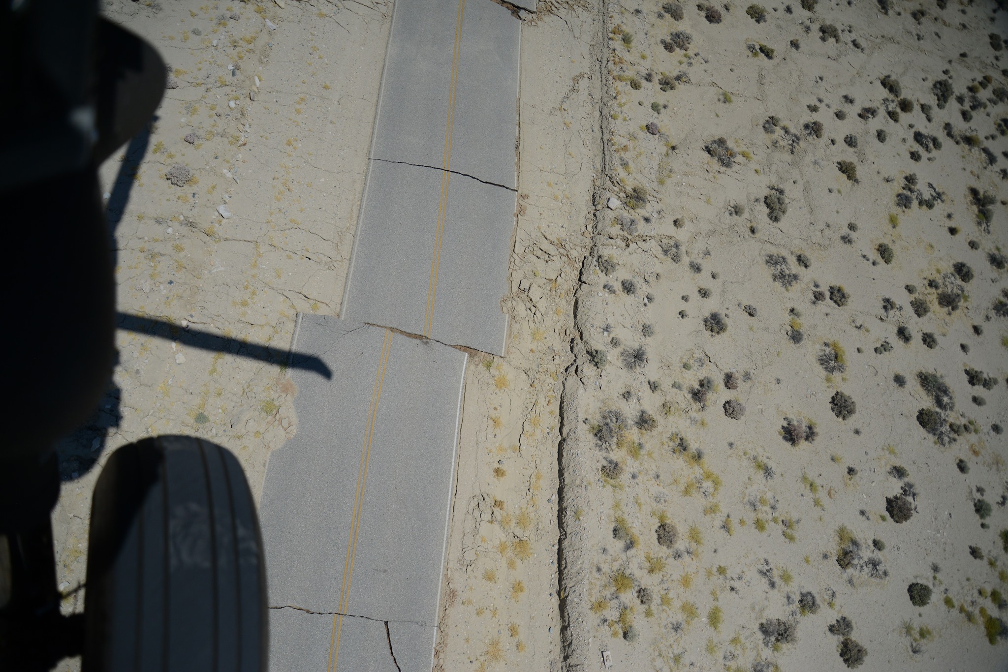
That changed with the magnitude 6.4 quake on July 4th near Ridgecrest, and the even bigger 7.1 quake on July 5th, which was the largest jolt to hit California in 20 years. Large earthquakes like those in the Ridgecrest area are capable of having a corresponding effect on other faults. Sometimes nearby faults “loosen up” and move as a result of a big quake, or sometimes they “freeze” and stay locked in place as the result of a nearby earthquake. But most of the time, nothing happens.
A good way to think of California fault geology is to imagine the state as a big, broken dinner plate that’s assembled back together, piece by piece, with a layer of topsoil on it. Some pieces of the broken plate are big chunks while other pieces are small, but they all move relative to one another.
The Garlock Fault runs about 15 miles to the south of Ridgecrest, cutting across U.S. 395 north of Mojave, and when the quakes happened near Ridgecrest this summer many observers initially thought they were on the Garlock. They weren’t. Instead, the Ridgecrest quakes were centered in a seismically active area called the Little Lake Fault Zone on a relatively unknown “strike slip” fault, which is a fault that moves horizontally and parallel to a surface fault trace. There may be hundreds of these unmapped faults around the state, some of which may not even be visible from the surface. In contrast, it was a similarly undetected “blind thrust” fault, which is a fault at an angle within the earth’s crust below the surface, that was the cause of the magnitude 6.4 Northridge Earthquake in L.A. in 1994.
While the Garlock Fault has historically been unaffected by nearby quakes with either an increase or decrease in stress, the Garlock is now moving, albeit very slowly, for the first time in centuries as a result of the Ridgecrest quakes. That movement, as detailed by the Los Angeles Times story, is a big deal in the Earth Sciences world. In seismology, this kind of slow, barely-detectable movement is called “fault creep,” or “creeping.”
In 1952, a large portion of Kern County and the southern San Joaquin Valley northeast of the Grapevine was hammered by one of the state’s most violent earthquakes. It was a big jolt, bigger than the biggest Ridgecrest quake, with a magnitude of 7.3. The quake and its aftershocks killed a dozen people, but that big earthquake happened on an otherwise little fault called the White Wolf Fault. The White Wolf had been identified and mapped prior to the 1952 earthquake, but no one was particularly familiar with it.
The White Wolf is also an east-west trending fault, located north of the Garlock but running parallel to its western end where it meets the San Andreas Fault at the Grapevine near Tejon Pass. Despite the violent shaking and proximity of the White Wolf Fault to the Garlock and San Andreas, the 1952 Kern County Earthquake didn’t seem to have any effect on either of those nearby fault systems.
Meanwhile, this summer’s Ridgecrest Earthquake Sequence certainly did effect the Garlock. The depth of the respective quakes may have had something to do with it, which is another reason the reactivation of the Garlock has become such a compelling story. While a bigger quake 65 years ago did nothing to affect the Garlock, the ones this summer near Ridgecrest rattled it loose. Maybe the Ridgecrest quakes were simply closer to a geologic “sweet spot” for the Garlock where it was “hung up” on rock, perhaps for centuries, and unable to move. Perhaps the Ridgecrest sequences avoided a more destructive quake. Perhaps some other geologic event has now been set in motion.
If you’re interested in further layperson reading, there’s a seismologist named Susan Hough — a very nice person but no relation — who works at the U.S. Geological Survey. She published a book in 2004 called Finding Fault in California: An Earthquake Tourist’s Guide, and it’s a handy book to have in the car on road trips or even if you’re just driving around L.A., as it points out all kinds of interesting seismic features in the state, some of which you can hike or drive right up to and see for yourself.
Grapevine banner photo by Tommy Hough © 2012 Tommy Hough, all rights reserved.
Ridgecrest earthquake photos courtesy of the U.S. Geological Survey.